
BADEN POWELL MACASSAR TRAFFIC CIRCLE
INTRODUCTION AND BACKGROUND
The City of Cape Town (CCT) proposes to upgrade the intersection of Baden Powell Drive, Macassar and Japhta K Masemola Roads, located at the eastern edge of Khayelitsha (the proposed project) (Figure 1). The proposed project entails a conversion of the existing stop controlled intersection to a roundabout. Baden Powel Drive has priority flow, and the traffic circle is intended reduce the delay experienced by current and future development traffic approaching from Japhta K Masemola and Macassar Roads and allow for safer right turn and crossing manoeuvres at this intersection. The project is being undertaken on behalf of the City of Cape Town in support of the Macassar Housing Development. A Transport Impact Assessment (ITS Engineers, 2012) was undertaken as part of the Macassar Housing Project, which identified that the Baden Powell / Macassar Road intersection is expected to operate over capacity during the
afternoon peak hour. A traffic circle was proposed to alleviate the expected congestion and improve traffic flow at the intersection.
Five erven are affected:
1. Remainder of Erf 18332, Khayelitsha (RE/18332)
2. Remainder of Farm Vergenoegd 547 (RE/547)
3. Portion 2 of Farm 547 Vergenoegd (2/547)
4. Portion 3 of Farm 547 Vergenoegd (3/547)
5. Remainder of Farm 544 Driftsands.
PROJECT PROPOSAL
The City of Cape Town (CCT) proposes to upgrade the existing priority-controlled intersection of Baden Powell Drive (R310), Macassar Road (M9) and Japhta K Masemola Road, located on the eastern edge of Khayelitsha, to a single-point roundabout (the “proposed project”) (Figure 1). The upgrade replaces the current T-junction configuration with a 44 m – 45 m traffic circle with two circulatory lanes, a truck apron, formalised public-transport stops, and Non-Motorised Transport (NMT) crossings with concrete/asphalt sidewalks on all four approaches. The two-lane circulatory roundabout will include two-lane approaches on all four legs, tapering back to the current single lane cross-section beyond the intersection on Baden Powell Drive. Lane widths are
generally between approximately 3.7 m and 4.0 m, and the total footprint of the project (including exiting roads) is approximately 20,900 m2. The exits along Macassar Road and Japhta K Masemola Road remain single-lane. The project is being undertaken on in support of the Macassar Housing Development. A Transport Impact Assessment (ITS Engineers, 2012) was undertaken as part of the Macassar Housing Project, which identified that the Baden Powell / Macassar Road intersection is expected to operate over capacity during the afternoon peak hour. A traffic circle was proposed to alleviate the expected congestion and improve traffic flow at the intersection.

Figure 1: Locality Plan
Two minor exemption subdivisions are associated with the road widening, to be deemed TR2 zoning in terms of Section 16(3) of the City of Cape Town Development Management Scheme. These are Portion 1 of the Remainder of Cape Farm 547 Portion 3 (about 161 m²) on the north west side, and Portion 1 of Farm 544 (about 2 765 m², of which roughly 1 650 m² is deemed TR2) on the southern side of Macassar Road.
DESCRIPTION OF RECEIVING ENVIRONMENT
The site is situated inside the Cape Town urban edge. Surrounding land uses are informal residential settlement in Khayelitsha to the south-west, undeveloped Cape Flats Dune Strandveld veld on RE/547 and RE/3/547 to the north-east and north-west, and the Zandvliet Wastewater
Treatment Works to the south-east. The natural vegetation to the north-east is classified as (1) Degraded to Highly degraded Strandveld and (2) Highly degraded to Transformed Strandveld. The existence of fragmented remnants of a depression wetland was confirmed within the project footprint, located to the west of Baden Powell Drive in the Khayelitsha informal settlement which extends up to the current edge of Baden Powell Drive. These have triggered the need for this Basic Environmental Assessment.
ENVIRONMENTAL ASSESSMENT PROCESS AND APPLICABLE LISTED ACTIVITIES
Due to the listed activities triggered by the proposed development, an Environmental Basic Assessment Report (BAR) process is required in application for Environmental Authorisation to undertake the proposed project. The Environmental Partnership (TEP) was appointed as the Environmental Assessment Practitioner (EAP) by The City of Cape Town to undertake this BAR. The Draft BAR has been undertaken in terms of the National Environmental Management Act (Act No. 107 of 1998) and associated EIA Regulations.
Listed Activities triggered by the proposed development are:
– Activity 19, Listing Notice 1. (GN R983 of 2014, as amended by GN R327): “The infilling or depositing of any material of more than 10 cubic metres into, or the dredging, excavation, removal or moving of soil, sand, shells, shell grit, pebbles or rock of more than 10 cubic
metres from a watercourse…”
– Activity 13. Listing Notice 3 (GN R985 of 2014 as amended by R324): “The clearance of an area of 300 square metres or more of indigenous vegetation except where such clearance of
indigenous vegetation is required for maintenance purposes undertaken in accordance with a maintenance management plan. i. Western Cape: Within any critically endangered or endangered ecosystem listed in terms of section 52 of the NEMBA or prior to the publication of such a list, within an area that has been identified as critically endangered in the National Spatial Biodiversity Assessment 2004; Within critical biodiversity areas identified in bioregional plans…”
As part of the BAR, three alternatives are being assessed:
1. Alternative 1: Preferred Alternative: Landscaped Traffic Circle, including two circulatory lanes, with all four approaches to the roundabout upgraded to two lanes per approach.
2. Alternative 2: Paved Traffic Circle, including two circulatory lanes, with all four approaches to the roundabout upgraded to two lanes per approach.
3. Alternative 3: No-Go Alternative, which implies that the project will not be realised. The proposed project requires an application for a water use license in terms of the National Water Act, 1998 (Act No. 36 of 1998). A General Authorisation is required as the road widening would encroach on existing wetlands and the working areas would place the wetlands at risk of being impacted, and trigger Section 21 c and i water uses.
SPECIALIST STUDIES UNDERTAKEN
Two Specialist Studies informed the BAR:
1. Botanical Statement, Capensis (2026). Greg Nicolson, Pr. Sci. Nat. (Botanical Science), This Study is supported by Full Botanical Assessment undertaken on the adjacent Farm RE/547 (Nicolson, 2022), which included fieldwork in 2014, 2017 and 2021 (Capensis, 2022).
2. Detailed Freshwater Ecological Assessment, EnviroSwift / Steytler (2026). Nick Steytler, SACNASP Pr. Sci. Nat. (Ecological Sciences),
KEY FINDINGS AND RECOMMENDATIONS
Biophysical Environment
The botanical assessment confirmed that the vegetation within the study area is Cape Flats Dune Strandveld, which is nationally listed as Endangered. However, vegetation within the proposed development footprint is largely degraded to highly degraded, with the western portion classified as degraded to highly degraded and the eastern portion as highly degraded to transformed. Approximately 500 m² of indigenous vegetation will be cleared as part of the proposed road upgrade. The development footprint falls outside the City of Cape Town Terrestrial Biodiversity Network (2024) and does not occur within a Critical Biodiversity Area (CBA). Although the adjacent Farm RE/547 is mapped as CBA 1a (irreplaceable), the proposed development footprint does not encroach into this area. One species of conservation concern, Erepsia dunensis (Endangered), has historically been recorded on a neighbouring property; however, the known buffer area for this species does not intersect the proposed development footprint. A pre-construction botanical walk-down is therefore
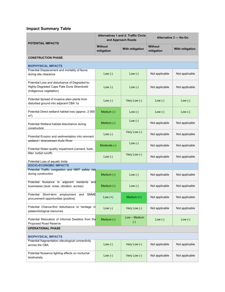
recommended to confirm the presence of any species of conservation concern within the footprint. Should any such species be identified, they must be translocated to suitable conserved habitat prior to vegetation clearance. Given the degraded condition of the vegetation and the limited extent of clearing, a biodiversity offset is not considered necessary. The freshwater ecological assessment identified two watercourses within the broader area of influence: the Kuils River floodplain wetland, located approximately 450 m downstream, which will not be directly affected, and a small depression wetland remnant located within the informal settlement west of Baden Powell Drive, which will be partially lost due to road widening. Approximately 2 000 m² of this depression wetland falls within the development footprint. The wetland is classified as having a Present Ecological State (PES) of Category F (Critically Modified), with a WET-Health Level 2 composite score of 8.2, indicating a severely degraded system. The wetland’s Ecological Importance and Sensitivity (EIS) was assessed as low to marginal, and the WET-EcoServices assessment indicated uniformly low ecosystem service provision. Given the wetland’s critically modified condition, low ecological importance, and highly transformed surrounding context, the specialist concluded that rehabilitation to a higher ecological category is not feasible, and that a wetland offset is not required in accordance with the National Biodiversity Offset Guideline (GN 48841 of 23 June 2023). The primary potential impacts associated with the development include loss of degraded vegetation, limited wetland habitat loss, and temporary construction-related disturbance. These impacts are assessed as low to moderate before mitigation and low after mitigation, provided that the recommended mitigation measures and the Environmental Management Programme (EMPr) are implemented. Overall, the specialists concluded that the development is acceptable from a biophysical perspective. Key mitigation measures include a pre-construction botanical walk-down, translocation of any species of conservation concern identified, and implementation of construction-phase environmental controls through the EMPr.
Socio-Economic Environment
The project area is located within a densely populated peri-urban environment between Khayelitsha and Macassar, characterised by a mix of formal and informal residential areas, relatively high unemployment levels, and strong reliance on public transport and major road corridors for access to employment and essential services. Baden Powell Drive functions as an important regional transport route supporting commuter mobility and economic activity. Temporary negative socio-economic impacts are expected during the construction phase, including traffic disruptions, noise, dust generation, and temporary access constraints affecting
nearby residents, commuters, and informal traders operating near the intersection. In addition, informal dwellers currently occupying the road reserve may need to be relocated during the construction preparation phase. This relocation impact is rated as medium significance before mitigation. With the implementation of a fair and transparent relocation process, provision of suitable alternative accommodation, and stakeholder engagement, the residual impact is expected to reduce to low to medium significance. Overall, construction-phase socio-economic impacts are assessed as moderate before mitigation
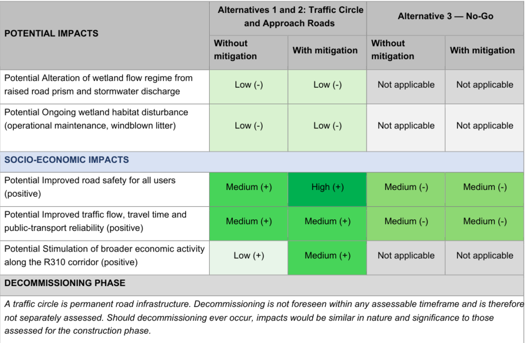
but low after mitigation, provided that a traffic management plan, dust suppression measures, appropriate construction scheduling, and stakeholder communication mechanisms are implemented. The project is also expected to generate positive socio-economic impacts, particularly during the operational phase. These include short-term employment and local procurement opportunities during construction, as well as long-term improvements in traffic flow, road safety, pedestrian accessibility, and public transport efficiency. Improved intersection performance is expected to reduce congestion and travel delays along Baden Powell Drive, enhancing connectivity between surrounding communities and key economic nodes. These benefits are assessed as having moderate to high positive significance, resulting in an overall net positive socio-economic outcome.
Heritage Environment
A Site Sensitivity Verification Report confirmed that the proposed development footprint has low heritage sensitivity, and no known archaeological, palaeontological, or historical heritage resources have been identified within the project area. The project involves upgrading an existing road intersection within an already transformed urban environment, which further reduces the likelihood of significant heritage resources occurring on site. The only potential impact relates to the chance discovery of previously unknown archaeological or palaeontological material during construction. This impact is considered low probability and low significance, provided that a chance-find protocol is implemented. Should any heritage material be uncovered during construction, work must cease in the immediate area and the relevant heritage authority must be notified, allowing a qualified heritage specialist to assess the find and recommend appropriate management measures.
PUBLIC PARTICIPATION
Public participation is a key component of the environmental assessment process as it introduces the proposed activity to the public and provides an opportunity for comments and concerns to be raised. Public participation will be undertaken in terms of Section 41 of the 2014 NEMA: EIA Regulations, as amended.
The draft Basic Assessment Report was made available to the broader public, identified Interested and Affected Parties (I&APs) and Organs of State for their perusal and comment from 19 August 2026 until 21 September 2026 by the following means:
● The draft BAR was distributed to the relevant Organs of State for comment via email (with a link for larger files, if necessary).
● The Information Sheet (summary of the BAR) was distributed to via email or hand-delivered to the following identified I&APs: occupiers of the site, directly adjacent landowners/occupiers and key I&APs such as the Ward Councilor and any Community Organizations in the area such as a Ratepayers Association.
● An electronic copy of the draft BAR and Information Sheet was placed on The Environmental Partnership’s website (www.enviropart.co.za).
● A media notice was published in the City Vision: Khayelitsha Edition local newspaper.
● Site notices were placed in conspicuous locations around the site.
● A hard copy of the draft Basic Assessment Report was placed at Macassar Public Library for the duration of the commenting period.
● Where written comments cannot be provided, provision was made for telephonic communication.
Second public participation iteration
The following will be undertaken for the second public participation iteration:
● Distribution of an Information Sheet (summary of the revised BAR) to registered I&APs.
● Distribution of copies of the revised BAR to relevant state departments for comment.
● Placement of a copy of the revised BAR on The Environmental partnership’s website, www.enviropart.co.za.
● Compilation of a Comments and Responses Table to document all comments received.
● The 30-day commenting period will commence on 19 August 2026 until 21 September At the end of the commenting period, all comments will be captured and addressed and included in the Final Basic Assessment Report (BAR). Proof of the Public Participation Process is appended to this revised BAR as AppendixF.
WAY FORWARD
All comments and concerns raised by I&APs in this commenting period will be addressed by the EAP and project team. Upon completion of the 30-day period, a PPP Report will be compiled and appended to the next revision of the BAR. The revised BAR will then be made available to the registered public for a further 30-day commenting period.
Comments on this report may be submitted on or before 21 September 2026 to:
The Environmental Partnership
5 Summit Way, Nova Constantia, Cape Town, 7806
Tel: 021 422 0999
Email: comments@enviropart.co.za
EAP IMPACT STATEMENT
The EAP is of the reasoned opinion that the proposed upgrade of the intersection of Baden Powell Drive, Macassar Road and Japhta K Masemola Road at the eastern edge of Khayelitsha, to a traffic circle (Alternative 1 – Preferred), should be authorised, subject to the implementation of the Environmental Management Programme (EMPr) and the mitigation measures contained in the specialist reports.
This opinion is based on the findings of the Basic Assessment process and supporting specialist studies, which indicate that the proposed development will occur largely within an existing road reserve in an already transformed urban environment. Although the broader vegetation type is Cape Flats Dune Strandveld (Endangered), vegetation within the development footprint is degraded to highly degraded. The footprint also falls outside the City of Cape Town Terrestrial Biodiversity Network and does not encroach into the adjacent Critical Biodiversity Area (CBA 1a) located on Farm RE/547.
Specialist studies further confirmed that a small remnant depression wetland adjacent to the road will be partially lost; however, the wetland is already critically modified (PES Category F) and has low ecological importance and sensitivity. Based on these characteristics, and in accordance with the National Biodiversity Offset Guideline (GN 48841 of 2023), neither a biodiversity offset nor a wetland offset is considered necessary.
Potential negative impacts associated with the proposed development include the loss of degraded vegetation, limited loss of wetland habitat, temporary construction-related disturbances such as noise, dust and traffic disruptions, and the relocation of informal dwellers currently occupying portions of the road reserve. These impacts are assessed as low to moderate prior to mitigation and low after mitigation. The relocation impact is expected to occur during the pre construction phase and can be effectively managed through a fair and transparent relocation process, appropriate stakeholder engagement, and the provision of suitable alternative accommodation.
The project will result in several positive socio-economic benefits during both the construction and operational phases. These include short-term employment opportunities and local procurement during construction, as well as long-term improvements in traffic flow, road safety, pedestrian accessibility and public transport efficiency. The upgrade will improve the operational performance of the intersection and reduce congestion along Baden Powell Drive, thereby improving connectivity between surrounding communities and economic opportunities.
No significant heritage resources were identified within the study area, and the site has been confirmed to have low heritage sensitivity. The only potential heritage impact relates to the unlikely discovery of previously unknown archaeological or palaeontological material during construction. This risk can be adequately managed through the implementation of a chance-find protocol.
The EAP therefore concludes that the proposed development is environmentally acceptable and that the preferred alternative should be authorised, subject to the implementation of the EMPr and the recommended mitigation measures, including a pre-construction botanical walk-down, translocation of any species of conservation concern if identified, clear demarcation of no-go areas, alien invasive species control, appropriate construction management, and independent environmental monitoring.




